Abyss Lake Fishing Spot
- Elevation: 893'
- Last Modified By: vinny60 on 01/29/10 08:46 AM
- Ask about Abyss Lake in our Fishing Forums
Photos
Fish Species
Comments
-
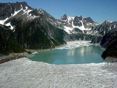
Abyss Lake is a lake in southeastern Alaska. A part of the Glacier Bay National Park and Preserve, its water is regularly blocked by an ice dam. When such a dam breaks in a glacial lake outburst flood, much of the lake's water is propelled into Dundas Bay, along with trees, ice chunks, and sediment. This has happened in 1994, 1997, 1998, 2000, 2001, 2005, and again in September 2006. The area around Glacier Bay in southeastern Alaska was first proclaimed a U.S. National Monument on February 25, 1925. It was changed to Glacier Bay National Park and Preserve in 1980 by the Alaska National Interest Lands Conservation Act. Glacier Bay National Park and Preserve is a United States National Park in the southern part of Alaska west of Juneau. The park area was included in an International Biosphere Reserve in 1986 and is part of a UNESCO World Heritage Site. The park covers 5,130 mi² (13,287 km²). Most of the park is a designated wilderness area which covers 4,164 mi² (10,784 km²) of the park. No roads lead to the park and it is most easily reached by air travel. During some summers there are ferries to the small community of Gustavus or directly to the marina at Bartlett Cove. Despite the lack of roads, there are over 300,000 visitors per year, most on cruise ships.
Abyss Lake Description
Abyss Lake is a lake in southeastern Alaska [1]. Lying on the eastern side of the Brady Glacier, it receives meltwater from it, which in turn flows into the Dundas River, Dundas Bay, Cross Sound and thence into the Pacific.